Little Oyster Creek
Beautiful, Historic, Unique
sandy islands move among this shifting water sometimes here, then there
Author: Lesley Newman, Virginia Certified Ecotour Guide
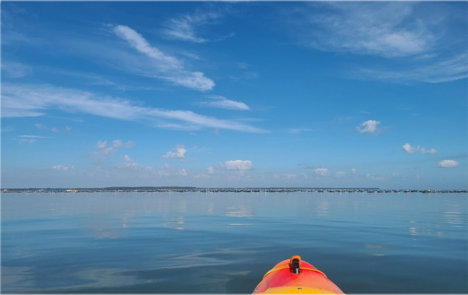
This water is never flat. Fleet’s Bay is nothing more than a scoopful of the Chesapeake Bay on Virginia’s Western Shore. It is loosely held by the embrace of Windmill Point and Bluff Point. When the infamous squalls that have frequently swallowed ships whip up the waters of the Bay, Fleet’s is also susceptible to the tempests. So, when I push through the aperture formed by the 695 bridge and spill over the sand spit that used to hold this point together, I do not expect the water to be slick. We used to talk about the river being slick, but I squeeze my eyes for dramatic effect when I find that today even the bay is slick. This vision is confirmed by the horizon line; with the water and the sky the same still colors of blue and gray, I can’t detect their boundary.
When I was a kid, this land was one long, thin point, but today, I will call it an island. When I was a kid, reporting the sightings of three bald eagles in these trees would have been labeled a tall tale. But that is something I can say with conviction is a true story in October 2020. The eagles aren’t the only fish predators in the area. In fact, the artificial oyster reef has drawn in a crowd. Several herons hang back shyly in Little Oyster Creek, but there’s a brief of brown pelicans, a flight of double-crested cormorants, many flocks of gulls, and two men fishing at the reef. The ospreys have left already, and the ducks and geese have yet to arrive.
Swimming season has passed us by, save for the very brave or very water-deprived. My partner and I pass on the opportunity this time. A kettle of vultures draws me to the shore, not because I have a magnetism to the macabre, but because I am an amateur naturalist in search of all of the things. There is a rotting carcass of the common bottlenose dolphin. I am not sad because this dolphin has died but glad because it lived in or near this bay, and I know from its presence that this is dolphin habitat, and that’s a good thing.
As an ecotour guide, it would be nice to plan for wildlife sightings, but that would remove the environment from our work. Many times on my tours I get just as excited about scat and bones because they’re signs that the animals are indeed in our environment.
Today we circumvent North Point (seen on one reference as Cedar Point, which is consistent with the presence of Juniperis virginiana) passing around the leeward side where boats tend to harbor. Three sailboats from points hither and yon rock sleepily in our kayak wake. No revelers stir on this late morning, but a pirate bar smacked together of worn marine boards grins toothily from the shore. We pass through the gut of the marsh separating Foxwells proper from Fleets Bay, and I see a pair of Callinectes sapidus, our beautiful and tasty swimming blue crabs, a school of minnows, and even a sugar toad.
This trip occurs primarily in brackish marsh, so there is a wide biodiversity of plants and animals. The fiddlers crabs scurry in and out on the mud flats within the marsh. Some of the island has retained remnants of maritime forest. Salty old pines draped with creepers bow overhead.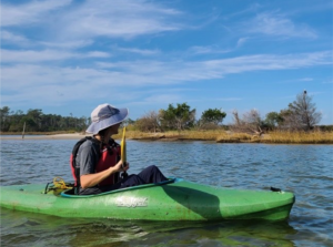
Pulling back into the haven at Westland, a breeze now comes in off the Bay. Returning to the landing is more difficult than going out was, but I smile. Such is the way of this water. As the wind moves around, so do the waves, the islands, the plants, the animals, and the people.
Highlights
As your tour guide, I take responsibility for planning our trip. However, in order to be best prepared, please take a few minutes to read the information in this blog so that we can plan for an excursion best suited to you and your group.
Beautiful, sandy beaches
There are a handful of public sandy beach accesses on the Northern Neck. Windmill Point has another sandy beach that is small with limited parking. It is a good place to watch the sunrise over the Bay if you are in the area at that time. The point that we paddle to is a lovely place to walk around and feel the sand in your toes. As I mention later, there is a more popular side of the island that is accessible on the route. It tends to be crowded on weekends and doesn’t have such an excellent view of the oyster reef.
Sandy beaches are an attractive feature even for us Northern Neck residents. These places allow us to get out and stretch their folded kayak limbs and perhaps take a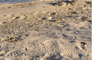 swim on a warm day. Sandy beaches are also essential nesting habitat for several endangered species, most notably the four species of sea turtles found in the Chesapeake Bay, and for a variety of shorebirds. As such, we will explore these areas gently and with a Leave-No- Trace mindset. This means that we will not impact the area in any significant way by collecting shells, building a fire, or harvesting grass or reeds. Because so many people and animals need our precious sandy beaches, we will do our very best to leave them as we find them. For more information on Leave No Trace outdoor ethics, please visit their website.
Historical Significance
This area is a good example of a Northern Neck watermen’s community. There are several historic oyster houses in the area. In addition, the mouth of Antipoison Creek empties into Fleet’s Bay. There are multiple references to the mouth of the Rappahannock in John Smith’s writing.
Unique Ecosystem
This manmade oyster reef simulates the ecosystem of a natural reef. The oysters themselves provide habitat for a number of different macro invertebrate organisms, including a worm that burrows into oysters’ shells. These food sources along with a rock-like structure with places to hide and reproduce attract fish at all levels of the food chain, which attracts larger predators like shorebirds and dolphins. Traveling through the brackish marsh reveals other nearby habitat where birds can live while feeding at the reef. Finally, the remnants of maritime forest and backyards of Fleets Island offer even more options for dwelling in this unique environment.
Maritime forests are a part of constantly changing estuarine shorelines. Historically, they protected shorelines from erosion during storms. Older growth trees can be a danger to human settlement as they are susceptible to high winds and lose branches during storms in all four seasons. While this area does not have an untouched density of forest, there are many pines, cedars, and wax myrtles that have withstood their fair share of salt spray from the Chesapeake.
Fleet’s Island
Once travelers cross a tiny bridge in Foxwells, they are officially on Fleets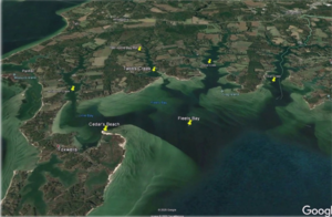 Island. As seen from a map or an aerial photo, the thin strand of sand we float over is the ephemeral tie to the contiguous piece of land that forms Windmill Point. This is low land, which in Bay country might mean that sunny day flooding occurs. It is not uncommon for parts of 695 to be underwater during a tidal surge or after a heavy storm. There are several old oyster houses and one currently running oyster company in this community.
The major settlement is a marina at Windmill Point Road and several condominium developments that have grown up around the marina. As an area with brackish marsh, some sandy beaches, tall pines stands, and human development, this is an attractive area for a wide variety of aquatic, terrestrial, and aerial species. Many raptors and herons favor the pines for nesting since they’re the tallest features of this landscape. With eyes in the canopy during spring on the short approach to the kayak ramp, one may be able to hear or spot eagle, hawk, and heron fledglings.
Post-Paddle Activities
While there is a bar and restaurant at the Windmill Point Marina, the town of White Stone offers the most venues for post- paddle refreshment. If you’re in the Northern Neck for the week or weekend, consider linking up with one of the Virginia Oyster Trail venues where you can learn more about oyster farming and aquaculture.
My personal favorite post-paddle venues are Willaby’s for beer and pub grub, Country Cottage for ice cream, Chesapeake Donuts for coffee and doughnuts, and the Old Farm Truck for planning dinner at home. If you’re looking for a dual activity day, check out the local bike trail map and let’s discuss bike/kayak logistics!
If you haven’t lured fish of your own, Miss Mary’s is a local seafood market. Rocket Billy’s has fried seafood and snack bar fare, and the Sandpiper is one of White Stone’s oldest restaurants.
Irvington is much more “on the map” than White Stone, but the casual atmosphere of the Tides Inn Oyster Bar “Fish Hawk” is a nice place to sit outside for the evening after your eco adventure. Dredge also allows casual diners, and you can try the sugar toads on the menu.
A change of clothes would be required for Adrift in White Stone, other parts of the Tides Inn, and The Office in Irvington.
While there are no hiking trails in the immediate vicinity, tours can also link up with overland birding trails. See this map from the Department of Wildlife Resources for birding options.
If you would like to plan for a longer paddle, we can map a route with a “dock-and-dine” option from this entry point or select another from the area!
If you are fishing, Savannah Joe’s in Kilmarnock will smoke your catch for you. Call ahead to verify: (804) 435-6000.
Other places where you and your companions can eat, drink, rest, and be merry are available on the Northern Neck Tourism Commission’s website.
Final Considerations
All major navigation tools are accurate for arriving at the Windmill Point Public Kayak Ramp whose address is listed as 000 Windjammer Lane and is directly off of Route 695. Route 695 forms the major intersection with Route 3 in White Stone. It begins as Chesapeake Drive and becomes Windmill Point Road after crossing Mosquito Point Road about three-quarters of a mile from the intersection in town. The ramp has a large gravel lot. No 4WD is necessary, but as always, you should watch for potholes. In addition, take precautions to secure your vehicle while you are out on the water.
As mentioned above, a number of factors influence the *difficulty rating* for this trail. Please check local weather and tide reports in order to pack before heading out. There is almost no shade on this trip, which should take 2-4 hours for both loops. In addition, there is a nice, sandy island where we can beach and explore. We will limit foot travel to this area and stay out of the marshes. These areas are fragile and important parts of the Bay ecosystem. Finally, the island is a popular destination for motor boats and weekenders. Those with small children might consider staying on the eastern side of the island where it is more private and there is less alcohol consumption taking place.
Trail Difficulty
Virginia Water Trails ranks this as a beginner trail, but please bear in mind that this is near the mouth of the Rappahannock and passes into Fleet’s Bay. Both bodies of water are very close to the Chesapeake Bay and as such, experience dramatic weather changes, strong tidal influence, and high winds.
Comprehensive trail info is available on the Virginia Water Trails website under Little Oyster Creek at Windmill Point (it is the green route in the Foxwells/ Westland area).
Activities
This trail is excellent for birdwatching. Avid birders might consider a fall, winter, or spring tour as the shallow bay is popular with migrating waterfowl and winter residents. Other activities include: beachcombing, swimming, and fishing. Fishing information is available through the local anglers’ club. There is also information on what species are in the area by season back at Virginia Water Trails.
“Little Oyster Creek is a little slice of heaven. This trip is great for families with youth ages 12 and up; there’s plenty to see and do. We really enjoyed the history and ecology lessons and look forward to our next trip!” ~ Satisfied customer
Contact
Lesley Newman, Executive Director
The Farkleberry Institute